 The flow of water in Englishman River was calm as I took a walk along the estuary. The wet banks were exposed and newly created sandbars and piles of stones lay exposed in the middle of the river, recently emerged from the water. An eagle, perched high in a giant Black Cottonwood, watched over a seasonal nest which looked like a massive bundle of large sticks wedges between the limbs of the tree. The tidal flats exposed by the low water was alive with an abundance of bird life. A gull dropped a clam on the stoney beach then swooped down upon the fresh meal.
Ten days ago, during three weeks of almost constant rain, the scene was completely different. The murky brown water was roaring and swollen high up onto the banks of the river. At several places the banks had been eroded by the water raging by at high speed and a number of large trees had been washed into the middle of the river. The tide was up, holding back the river, causing much of the estuary to be flooded by fresh rain water flowing over areas that normally look like grassy fields.
My father and I launched a canoe into the water gushing out of a concrete and steel storm drainage that slows the surface water coming off the streets of the City of Parksville. We floated with the current into a series of swollen canals that separate the community park from the wildlife reserve which is protected and managed by Nature’s Trust. Along the shore we could see the landfill that has been dumped by Surfside RV in order to expand their parking space for RVs and mobile homes.
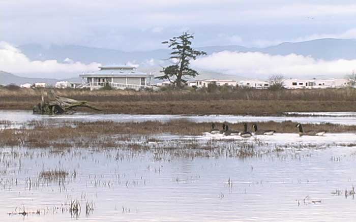
We drifted slowly in the canoe through the unique ecosystem that is an inter-tidal floodplain, a place were the fresh water of the Englishman River watershed meet with the salt water of the Strait of Georgia. The constant ebb and flow of the tides mix with the replenishing flow of river water. An abundance of shoreline vegetation attract many species of birds, even in winter. The near silent movement of the canoe allowed us to approach waterfowl without disturbing them and identify Bufflehead, Western Sandpiper, Surf Scooter, American Coot, Canada Goose, Mallard Duck, Common Merganser, Belted Kingfisher, Common Goldeneye, and Great Blue Heron.
A few days ago the same storm drain ditch entering into the back eddies of the estuary contained a mere trickle of water. The low tide revealed mud flats edged by thick green vegetation teeming with life. This sensitive ecosystem is one of the most endangered on the planet since much of the human development occurs on the estuaries of river systems.
Federal, provincial, and city governments have committed to protecting the estuary of the Englishman River. The public must hold them to their word because private developers will always eye this wildlife reserve as a profitable piece of real estate. Encroachment continues as you read this article. One look at the rock causeway built by Surfside RV along the beach, which holds back the tide despite Federal Crown ownership of the shoreline, shows the priority of private enterprise. In the near future encroachment may come under the mask of an interpretive center proposed to build a bridge over the inter-tidal canals encouraging thousands of people to walk through the delicate and fragile environment. Surfside RV is the prime advocate for this project. lobbying city council and other levels of government, and they stand to gain a backyard for their paying customers at the expense of the wildlife reserve.
To show your support for the protection of the estuary please contact the City of Parksville at: 248-6144 or www.city.parksville.bc.ca
Follow-up and Backgrounder
In 2001 I attended a power-point presentation in the CIty of Parksville Council Chambers made by Dr. Glen Jamieson along with the owner of Surfside RV. Together they outlined a proposal to develop an interpretive center, vehicle parking lot, tourism building, and bridges to access the natural wildlife reserve located on the estuary of the Englishman River. They were looking for support from city hall as well as invited guests in attendance who represented Nature’s Trust, Duck’s Unlimited, Environment Canada (The Canadian Wildlife Service - Species at Risk), COSEWIC (Committee on the Status of Endangered Wildlife in Canada), Fisheries and Oceans Canada - Pacific Region, BC Ministry of Environment, Mount Arrowsmith Biosphere Society, Streamkeepers, Arrowsmith Watershed Coalition Society, Save Georgia Strait Alliance, and the Pacific Estuary Conservation Program.
The overwhelming reaction to these plans were negative. Government agencies and none-profit-societies brought up the fact that the wildlife reserve was established to limit the human impact upon a sensitive ecosystem and the wildlife that if provided for in the form of nesting habitat, feeding grounds, and resting areas. The plans were rejected by all levels of government at that time. At the conclusion of that meeting, then Mayor of Parksville Julia MacDonald, made it clear that this was a private issue that would not be effected by city policy.
However, Surfside RV and Dr. Glen Jamieson continue to lobby privately for their development plans in the estuary reserve. In fact they have made false claims to potential investors that they have the full support of the City of Parksville. Any support the city gives to their proposal will bolster their chances and directly effect the future health of the Englishman River Estuary Reserve. The citizens of Parksville believe that the estuary is protected from any further development. Many citizens lobbied hard for many years to raise the money that eventually acquired the land that is now a wilderness reserve in the middle of the City of Parksville. Naturalists, bird watchers, and other outdoors people come here specifically to observe the Englishman River Estuary Wilderness Reserve. They bring economic prosperity with them. Today there are new plans to build a trail accross the estuary to connect the shorline with an extensive trailsystem. The attacks on this limited ecosystem never seems to end.